Friday 29 March 2013

Law of the Indies


The Law of Indies, created in 1573, was constructed as guidelines for the Spanish on how to find and build new cities in the Americas.
The Settlement of Ordinances within the Laws of the Indies tells us that Spaniards articulated what newly founded cities looked like by specifying what good areas to inhabit were. In order to populate an area, The Settlement of Ordinance required that the land be chosen based on the health of the original inhabitants and their animals, the climate, fertility of the land, distance to water supply, elevation, and number of resources available.
Also, The Settlement of Ordinances requires that once the governor sites a new settlement, people who are willing to also register and live on the land are granted units of land in the form of peonias and caballerias, which they will use to build on. A peonia lot is 46 feet wide and 92 feet deep. The land will ideally yield 156 bushels of wheat or barley or 15.6 bushels of corn. A caballeria lot is 92 feet wide and 184 feet deep. This land will has the potential to harvest 780 bushels of wheat or barley or 78 bushels of corn.
Additionally, the size of the central plaza must be proportional to the number of inhabitants living in the settled area. The suggested size stated in The Settlement of Ordinances is 600 feet long and 400 feet wide. The plaza must also be square or rectangular and be placed at the port landing.
The grid-like space must also be organized according to hierarchy. The central area is where all the common meeting place is. The buildings that surround it consist of important buildings like cathedrals, temples, and royal councils. Less important buildings, like residential housing, slaughter houses, and tanneries are placed further away from the centre. 

Works Cited
Gasparini, Graziano. The Law of the Indies - The Spanish-American Grid Plan: The Urban Bureaucratic Form. 
Friday 22 March 2013

Urban Spain


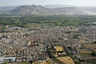
In the fifteenth century, Spanish urbanism experienced a dramatic transformation due to the Catholic monarch take-over of the Islamic Emirate of Granada. This event marks the completion of the Reconquista (a century long conquering of the Iberian Peninsula by the Christian kingdoms from the Islamic kingdoms in the Middle Ages) and its effects on the architecture and urban planning of the Iberian city. The dramatic design changes seen in the old city of Granada can be contrasted with Santa Fe de Granada, which was constructed as an encampment set up by the Catholic monarch after the Spanish conquest of Granada. 

 Aerial View of Santa Fe, in the Province of Granada. http://www.123rf.com/photo_9762353_aerial-view-of-santa-fe-in-the-province-of-granada.html.


By analyzing Granada and Santa Fe de Granada (Fe refers to the Catholic faith), it was evident that the layout of Santa Fe  follows a grid plan centered around two main roads that intersect at the centre plaza. In contrast, Granada follows an organic layout, which reflects their disarray and inevitable destruction. Since Santa Fe was constructed as an army base for the Spaniards, it would probably function like the Wari military centre of Pikillacta, now in modern Peru. The grid system represents order and stability for the military base. As well, by having a grid system, it makes the control of the movement of citizens throughout the area

The architecture within these two locations also differs a lot. In Granada, with the growing involvement of the Catholic faith, many of the Islamic mosques were converted to Christian churches or completely torn down. This transformed the urban landscape in Granada due to all the cathedrals being put up. The architecture in Santa Fe served as a place for the Spanish Catholic monarch; therefore its landscape consists of many churches and monuments. The design elements within Santa Fe also reflect Renaissance style.

Similar to the Spanish conquest of Tenochtitlan in Mexico, the Spaniards continued their tradition of destructing and re-constructing the overthrown area of Granada with the creation of Santa Fe de Granada. This was done to symbolize the clearing out of old religions, beliefs, and traditions in order for their own Catholic traditions to be incorporated into society.

Works Cited

Friday 8 March 2013

The Burial of Tenochtitlan


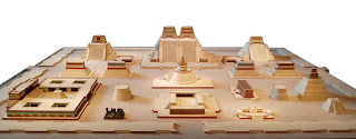
This week’s blog, I travelled to the ancient city of Tenochtitlan and modern day Mexico City using Google maps. The reason for this visit was to compare the size and scale of the Aztec capital to the colonial Mexican capital, and to generate my own reasons for why Tenochtitlan was buried under the Mexican capital.

Model of Tenochtitlan. http://www.tenochtitlanfacts.com/.
 
The Aztec imperial capital of Tenochtitlan stood out as the largest urban center in the twelfth to fifteenth century. Organized into quadrants, it spanned over twelve kilometers squared. Unfortunately, between 1519 and 1521, this magnificent city experienced a massive fall due to Spanish take over lead by Hernán Cortés. Following the destruction of Tenochtitlan, the Spaniards decided to build their own metropolis over the ruins in a more European style. The size of Mexico City has far exceeded the size of Tenochtitlan due to the ever expanding population. Most of the buildings in Tenochtitlan were torn down by the invaders in order to incorporate more buildings and housing. However, through recent excavation, Templo Mayor (the Great Temple) and other artifacts were revealed beneath Mexico City.
I believe the Spanish conquered the area and built on top of the ruins because at the time, Tenochtitlan’s size, power, wealth, and legitimacy were very enviable. Being the biggest of all the Aztec cities draws in a lot of focus not just because it was considered the main administrative center and marketplace, but it also poses as a target for attack. It would show the strength and power of an incoming army if it was able to conquer and dismember such a massive empire. Therefore, building on top of Tenochtitlan could have signalled new order.
Another reason that could have fuelled the extensive effort of Spanish leader to destroy the remains of Tenochtitlan could be because he wanted to purge the old city of their religious/cosmological beliefs. This would allow for Christianity to be incorporated into the new city as the preferred religion for the inhabitants.
Whatever the reason may be, it is sad that so much of the history of Tenochtitlan, found in the ruins, is lost because of the Spanish takeover to build Mexico City.

 
Works Citied


History and Facts About Tenochtitlan. http://www.tenochtitlanfacts.com/.

King, Heidi. "Tenochtitlan". In Heilbrunn Timeline of Art History. New York: The Metropolitan Museum of Art, 2000–. http://www.metmuseum.org/toah/hd/teno_1/hd_teno_1.htm  (October 2004).


Saturday 2 March 2013

Did the Toltecs really invade Chichen Itza?


Many scholars have tried to make connections between Chichen Itza and the Toltecs because of the similar traits they see in building construction and decoration.  To investigate, I took a virtual tour of the Mexican sites of Tula, Hidalgo and Chichen Itza, Yucatan to observe the similarities and differences between Pyramid B and the Temple of the Warriors, respectively.
 
Tula.


Chichen Itza.


Both sites contained similar militaristically styled architectural sculptures significant to the Toltec culture. The four tiered pyramid with down-flying serpents and numerous ornately decorated “Atlantean” stone men are some of the features found at both sites. However, it was evident through aerial views that Tula had a much smaller and less complex landscape compared to Chichen Itza.


Looking at Pyramid B in Tula, Hidalgo, it contains four stone columns at the top, carved in the form of Toltec warriors. Some faded red pigments can still be seen on the columns meaning they were once painted to emphasize the elaborate details. There were also carvings of eagles, jaguars, serpents and coyotes (Wall of Snakes) along the base of the structure. These carvings suggested the Tula peoples’ power and ability as warriors. The vestibule that connected Pyramid B to Pyramid C was filled with broken round columns that once held a roof. This provided shade for the procession of priests and nobility between the pyramids.
 

Archaeological Site of Tula, Hidalgo.


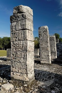
Temple of the Warriors in Chichen Itza, Yucatan possesses a different layout at the temple summit. As soon as you enter the top tier, you are confronted with a chacmool statue. This reclined figure has an awkwardly strained neck and an empty plate laid on top of his stomach. This could have been used as a surface to provide offerings of food. Rows of S-shaped serpent columns also line the top of the pyramid, which were probably used to hold up a roof. Along the broad stairway are ramps on either side with carvings of figures holding flags. This implied the processional flow of people up the pyramid. The sea of square pillars at the base of the pyramid each depicts carvings of warriors and tribute items in low relief.

 
Chacmool, Temple of the Warriors.
Temple of the Warriors.
 
I am unsure whether there was a Toltec migration or invasion of Chichen Itza but the uncanny resemblance of the architecture suggests a strong Toltec influence. This would make any traveller to the two sites believe they were visiting the same site in two different locations.
 
Works Cited:

Jones, Lindsay. "The Hermeneutics of Sacred Architecture: A Reassessment of the Similtude Between Tula, Hidalgo and Chichen Itza, Yucatan, Part 1." Chicago Journal 32 (February 1993): 207-232.  http://jstor.org/stable/1062996.
Kristan-Graham, Cynthia. "A Sense of Place at Chichen Itza." In Landscape and Power in Ancient Mesoamerica, edited by Rex Koontz, Kathryn Reese-Taylor, and Annabeth Headrick, 327-359. Boulder, Colo. ; Oxford : Westview Press, 2001.
Tula (Tollan). http://www.on-the-matrix.com/north_america/Tula.asp